Conversion of map coordinates
#1

I have a bunch of After Action Reports and they all give very specific locations for things that were happening. I'm trying to figure out if there is a way to convert those coordinates into lat/long so I can find those locations. Has anyone had any luck with this? I'm not sure if it is even possible...


An example:

Dragline 3 wants signs "Danger Mines, road not cleared" at 276863


Thanks for any advice on this!

Reply
#2

I hadn't had time to see how much this corresponds to what we use today (Military Grid Reference System) but it looks very similar. Here is a link to a WWII land navigation pub that will tell you how it works.

https://archive.org/details/Fm21-26

Maj Todd O. USMC, Retired
Grandson of LTC John O'Brien
Reply
#3

Cool!

Marion J Chard
Proud Daughter of Walter (Monday) Poniedzialek
540th Engineer Combat Regiment, 2833rd Bn, H&S Co, 4th Platoon
There's "No Bridge Too Far"
Reply
#4

Thank you for the information. I'll read the FM and see what I can come up with.

Reply
#5

One of the best places for help that I have found has been the website located here http://www.echodelta.net/mbs/eng-translator.php The link actually takes you to the coordinates translator which, when the information is entered correctly, will give you the latitude and longitude as well as maps (including an interactive google map) of the coordinate entered.


The first thing you must do is find the specific geographical coordinate system to use. If you are familiar with where the unit that you are working with is located, it will be easy to fine here... http://www.echodelta.net/mbs/eng-overview.php


For an example, the November 23, 1944 entry for B company of the 157th Engineer Combat Battalion states “Completed by-pass and bridge repair at Grandrexange, (Q405100)”. I know approximately where they were located and after conferring with the geographical coordinate systems I can confirm that they were in the In the Nord de Guerre Zone. (luckily for the 157th, they were pretty good in identifying which coordinate system they were in) Using the coordinate translator (the first link above) you must first change the grid location to “Nord de Guerre Zone”.


a_zpsf7a56889.jpg


The next step is to enter the coordinates. This must include two letters followed by six numbers. This is the tricky part because the 157th notes usually only contain one letter and six numbers (occasionally only 4 numbers). Based on your example, your unit did not appear to have included any letters. Again, if you know where your unit was, you can look further into the subdivided zones (shown in the second link provided) and try to determine which two letter square they were in. Since the 157th example had the letter "Q" and knowing approximately where the company was at the time, I was able to determine that the Q should actually be WQ. Luckily there are six numbers in this example so in the translator, add the code WQ405100 (no spaces) and hit convert. I have included an image of the google map showing the location being right next to an overpass in Grandrexange.


b_zpse70accac.jpg


As I mentioned, it is not the easiest to use and there are a number of tricks that I have found to help when you do not have complete codes. If i recall correctly, the website does give a few hints at trying to figure out the full code but the more you mess around with it, the easier it becomes. Good luck!


Brian


Reply
#6

Brian,


Thank you for the very detailed and well explained answer!! Amazing! I do know where they were (approximately) throughout all of their time in Europe.


I'll devote some quality time to this over the weekend! Exciting stuff!


Mikel

Reply
#7

Oooooo, I will have to try that. This is very cool. I can see getting wrapped up in this for hours at a time...

Marion J Chard
Proud Daughter of Walter (Monday) Poniedzialek
540th Engineer Combat Regiment, 2833rd Bn, H&S Co, 4th Platoon
There's "No Bridge Too Far"
Reply
#8

Good stuff!

Maj Todd O. USMC, Retired
Grandson of LTC John O'Brien
Reply
#9

I have a bunch of After Action Reports and they all give very specific locations for things that were happening. I'm trying to figure out if there is a way to convert those coordinates into lat/long so I can find those locations. Has anyone had any luck with this? I'm not sure if it is even possible...


An example:

Dragline 3 wants signs "Danger Mines, road not cleared" at 276863


Thanks for any advice on this!


Mikel, it's possible. If you give me more info about your documents, I can extend the map I've started to cover the area you're interested in. I used echodelta.net to make the map, now I use the map as a quick reading reference without having to translate every point all the time.


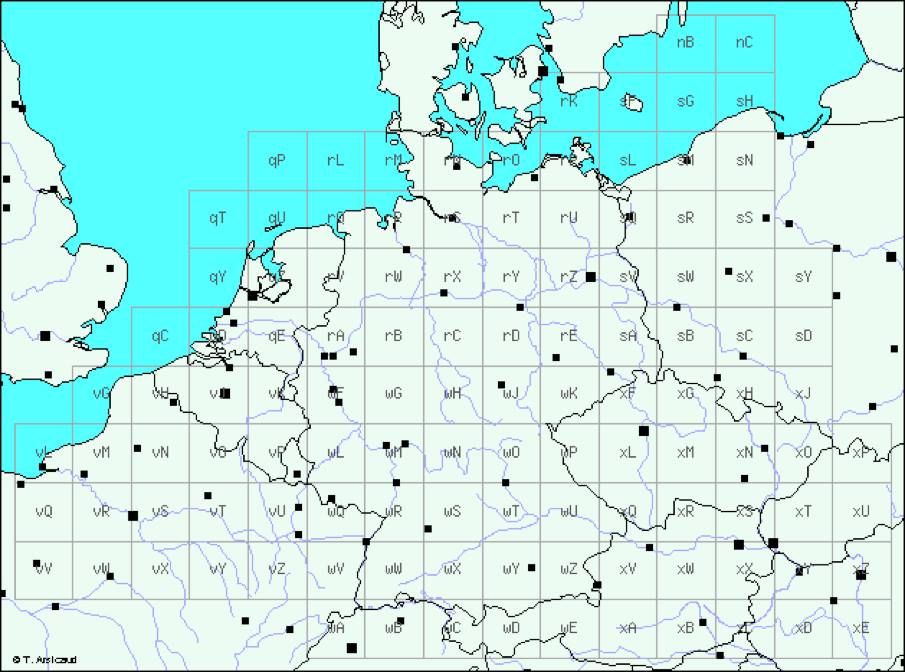
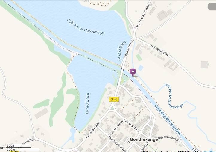
I've been working on it for about a year. Brian is right to point you to echodelta.net. It's the only source for World War II coordinates that I've found. Most web references for the grid system refer to the Cold War era grids which are different. Brian's explanation of how to use the system is good too. By using the grid translator at echodelta and some original maps I created an overlay of the north east corner of wQ on a google map. The longs/lats produced by echodelta have a margin of error 150 to 1000 meters, but I cross referenced the results of the translator with some original field maps I have access to and added my own calculation to correct the margin of error. It works very well for me: Nord de Guerre Grid wQ


This is for my interest in the Battle of Reipertswiller (Jan '45) which happened to include the 36th Engineer Regiment. It's on the same map grid that Brian mentioned above. The Facebook group for the 45th in WWII has collected hundreds of documents from the Archives; monthly journals, S-2 reports, war room journals, after action reports etc. They're like minute by minute diaries, most with grid references. The map I made is a handy reading reference as I'm reading the documents. One of the documents, the 36th Engineer sitrep for Jan'45, is also hosted here at the VI corp site and the grid locations in that document can be found on the google map I made.


I made the map by using the translator at echodelta to plot the edges of the area I'm interested in in 1000 meter intervals. I then used the google map line function to snap lines between opposite points giving me a grid of 1 kilometer squares. In the area of battle, I subdivided further in 200 meter squares.


The six digit numbers are precise to 100 meters. To find coordinate 839413 I have to find the intersection of easting 83 (vertical line) and northing 41 (horizontal line). That gives me the zero point for grid 8341. The zero point of grid 8341 is the southwest corner of the square. Then it's 9/10ths to the right and 3/10ths up. I've now located 839413 and within 100 meters of the spot being referenced. 835415 is in the center of grid 8341. Sometimes you'll get an 8 digit number which means the location is trying to be precise to within 10 meters. Four digit numbers were used to locate assembly areas for large units, depots and headquarters without being too precise. You find the most use and most precise grid numbers in artillery reports. When a unit moved from one grid to another, like from vU to wQ you usually see a mention of that in the journals, because it meant you needed a whole new map, but it's a one time mention as the unit is moving.


There are obvious cautions about plotting document entries absolutely. Coordinates were generated in the field, sometimes under fire, so mistakes were made. One of the problems in the battle I'm studying is that a key company's CO was killed and the company was completely lost. For two days they said they were at a certain coordinate, but they were actually 2 kilometers off. You're also following a game of telephone. By the time a coordinate worked it's way up from an artillery FO to battalion, to Regiment, to Division, the number might have been mixed up. I've seen plenty of just plain typos that obviously transposed digits to a location 20 kilometers away.


So yes, possible. And neat.

Reply
#10

Thank you for your post. Very interesting. So fascinating and revealing. This will help so many people who have questions. Ah, recognized Baerenthal immediately.

Marion J Chard
Proud Daughter of Walter (Monday) Poniedzialek
540th Engineer Combat Regiment, 2833rd Bn, H&S Co, 4th Platoon
There's "No Bridge Too Far"
Reply


Users browsing this thread: 1 Guest(s)