04-26-2006, 06:49 PM
Taken from the Lone Sentry Site:
http://www.lonesentry.com/usdivisions/days_combat.html
Note: This only covers the days in combat for U.S. Army Divisions in Europe, North Africa, and Middle East, NOT PACIFIC.
Taken from the Lone Sentry Site:
http://www.lonesentry.com/usdivisions/days_combat.html
Note: This only covers the days in combat for U.S. Army Divisions in Europe, North Africa, and Middle East, NOT PACIFIC.
US Army Inf Divisions WWII - a list

US Armored Divisions - a list

US Airborne Divisions - a list

US Cavalry Divisions - a list

Bombarding you guys with info. This from Wikipedia...
http://en.wikipedia.org/wiki/List_of_Unite...ng_World_War_II
Answers.com list of divisions - Army and Marine Corps
http://www.answers.com/topic/list-of-unite...ng-world-war-ii
Okay, now for some FUN!!! Wanna play a game? Well it's a quiz! 

Hey we should make up our own huh? Now that would be fun...
http://www.answers.com/topic/list-of-unite...ng-world-war-ii
Gee. I wish I had a place to hang it. I've got so-o-o many real maps that I can't hang them. I am planning to hang a very colorful "silk" escape map that I just got.
Let me show you one of several maps I recently obtained. These are field maps used by infantry and artillery commanders that have the grids and topography. BUT this one is made from Aerial Photographs. It is 1:12,500 scale, which is the lowest scale that they made and it is marked with the same identification & coordinates as the regular grid maps. The largest scale would be identified with a Number such as 87. Then these would be divided into quadrants at 1:50,000 scale with a Roman numeral identifier. Then they were sub-divided into 1:25,000 scale maps and identified with 2-letter compass identifiers---so we are now at 87-II NW. This one is even further divided into the smallest scale and have a lower case letter in ().
This one is a map of southern half of Bologna and identified in upper RH corner as 87-II NW (a) , and the scale at the top margin. This is, of course, only a small corner of the map. The grid coordinates for the middle letter "O" in Bologna would be 872-485.
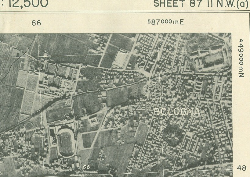
Scale: 1:12,500 (1 inch = 694 yds)
Size: 22.5 X 20 inch. (Each grid square is about 3-1/4 inch per side)
Dated: February, March April, 1945.
Town, Mtn & River names and Grids and topograghy are overlayed on the photo in black & white.
Further down on this sheet, you can clearly see a cluster of bomb craters where Hiway 64 crosses the river.
Cool, eh?
Steve
Marion, Get the book,"Dogfaces Who Smiled Through Tears", see page
640. It is an accurate account of the 34th. "Red Bull",Divn. and it
also includes it's casualties. I was with them from April '43 to Oct.'45
"Mere" I stand pat with the book. Love,Rocky